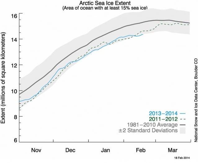
Despite the fact that large parts of the Arctic region have not been warmed by the sun for many weeks, sea ice extent in the far north dipped to record low levels in February. On the 18th, sea ice covered 5.544 million square miles of the Arctic, while the previous low on that date was in 2006, at 5.548 million square miles.
The National Snow and Ice Data Center reported that in January, average sea ice extent was 5.30 million square miles, which was 309,000 square miles less than the 1981-2010 average. This happened as temperatures in the region rose above normal levels.
As the shifted polar vortex caused temperatures to drop to colder-than-recent-normal levels in the eastern half of the United States, Arctic temperatures have spiked. From the beginning of February through Monday, Arctic temperatures were between 7.2°-14.4°F above normal.
“Right now, the Arctic is pretty warm everywhere,” National Snow and Ice Data Center senior scientist Julienne Stroeve told Climate Central. “If I look at temperature anomalies, there’s a huge anomaly over the Barents Sea and Sea of Okhotsk of about 10°C (above normal) compared to 1981-2010.”
This week much of the continental United States is seeing a dramatic thaw from freezing temperatures, raising concerns of flooding as the snowpack melts.
January was a very cold month for large parts of the U.S., but no state had a record-cold month — and the warmth in the West almost balanced the cold in the East for a slightly below-average (0.1°F) contiguous U.S. temperature. Meanwhile, Alaska had its third-hottest January on record. Projections for next week show that large parts of Alaska have a 70 percent likelihood of above-average temperatures even as the polar vortex shifts back down to bring cold temperatures to the the U.S. west of the Rockies.
The Arctic has warmed by 2°C (3.6°F) since the 1970s. NOAA recently warned that by the end of the century, the Arctic could warm by 13°C — or 23°F. This would likely mean an ice-free Arctic in the summer.
September ice levels are usually the lowest for the year, and the recent trend has been a13.7 percent decline per decade, according to the Arctic Report Card released last September.
Even though the most common way to measure Arctic sea ice is by the area it covers — extent — it can also be measured by how thick and old it is. NOAA found that thick multi-year ice has declined from comprising 26 percent of the overall ice pack in 1988 to only 4 percent of it by the end of last winter.
As the ice disappears from the Arctic, the U.S. military sees another place it has to defend,unveiling a comprehensive Arctic Strategy in November of last year.
One of the reasons that the Arctic can be so warm when there is so little light is because ocean temperatures have been warmer than normal — and part of the reason for this has to do with its color. A study released earlier this week confirmed that sea ice has dwindled because there is less of its bright whiteness to reflect back sunlight into space. As the ice melts, more of the surface area changes to darker ocean water, which absorbs the sun’s energy, warming the ocean and allowing more ice to melt.
Some researchers believe that less Arctic ice means the jet stream can bring more stormsinto contact with the U.K., which has been pelted with extreme flooding and strong winter storms recently.
Source: Climate Progress. Reproduced with permission.


