- Australia posted its second-warmest September on record as the powerful El Nino event in the Pacific continued to scale new heights, the Bureau of Meteorology said.
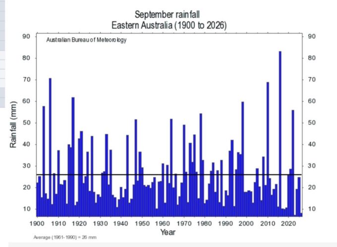
Eastern Australia collected its second-lowest September rainfall since national temperatures records began in 1910.
For mean temperatures, Australia last month was 2.71°C warmer than the 1961–1990 average, lagging only the 2.71°C anomaly recorded in September 2013, the bureau said.
For maximum readings, September came in as Australia’s third warmest. For minimums, last month narrowly pipped 2020 to become the mildest September on record.
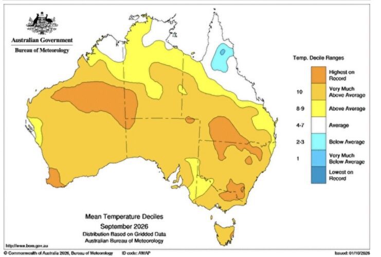
- Australia is primed to set fresh records for warmth given climate change has lifted average temperatures about 1.5°C since 1910, when the bureau was established.
This year, however, a monster El Nino event has been developing in the Pacific.
During such events, global temperatures tend to get an additional spike, lifting the odds 2026 will be the hottest on record since the introduction of reliable measurements more than a century ago. Given the system’s lags, 2027 will probably be warmer again, according to CarbonBrief, among others.
While El Ninos tend to bring drier than usual conditions for Australia, every event differs. The influence from other oceans surrounding the country, particularly the Indian Ocean, can counter the rainfall signal coming from the Pacific.
September, though, was relatively dry, with area-averaged rainfall 17% below the 1961–1990 benchmark. NSW posted its fourth-driest September since national rainfall observations began in 1900, the bureau said. Western Australia, though, had its second-wettest September on record, with the area-averaged rainfall 147% above average.
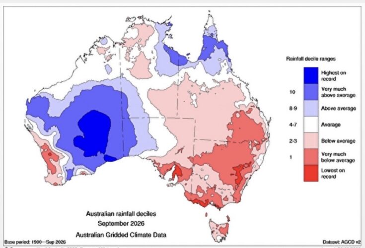
For eastern Australia, though, September was starkly drier than usual.
The average rainfall of 8.32 millimetres across eastern Australia was down about two-thirds from the long-term norm. Only the 7.39mm average rainfall recorded in September 2023 was lower.
Rainfall in recent days in Melbourne and across Victoria will go some way to ease drought concerns and the fire risks of the coming summer.
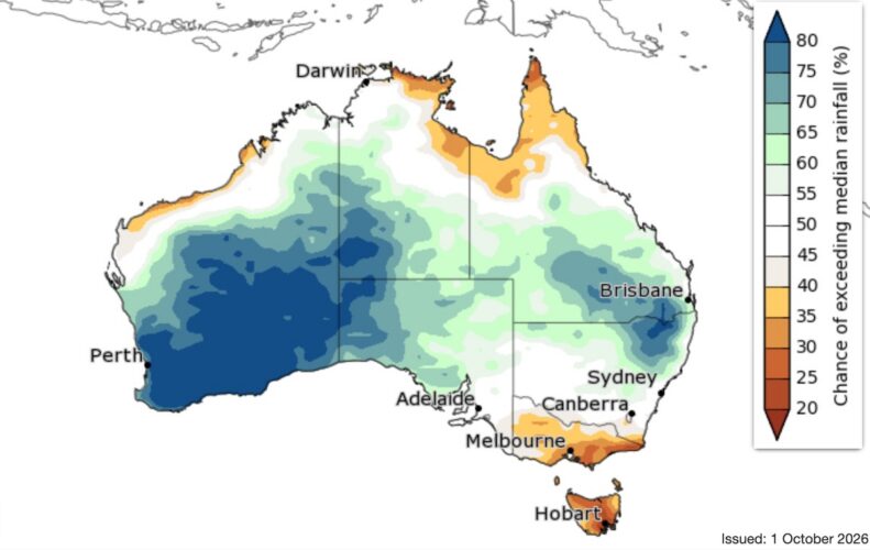
For now, though, the bureau’s longer term outlook for both October-December and November-January point to odds favouring drier-than-usual conditions in Victoria, at least.
“Below average rainfall is likely (60 to 80% chance) for much of southern and eastern Victoria, Tasmania, and northern parts of the Northern Territory’s Top End and Cape York Peninsula in Queensland,” the bureau said, in its latest summary released on Thursday.
“For much of eastern Australia and parts of the north, there are roughly equal chances of above or below average rainfall for October to December,” it said.
Maximum and minimum temperatures, though, have odds pointing to warmer than usual reading across almost all of Australia for October, October-December and November-January periods, the bureau said.
Internationally, meteorologists continue to be amazed by the strength of the developing El Nino.
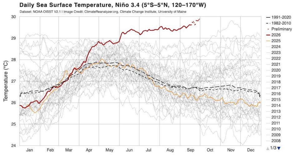
Daily readings gathered by the US’s National Oceanic and Atmospheric Administration and posted on the Climate Reanalyzer website, show that sea-surface temperatures in the El Nino 3.4 region of the equatorial Pacific to be at record highs.
They now exceed the previous record high set in 2015, about two months earlier than that peak, in data going back to 2008.
The bureau noted that “[a] strong El Nino signal in the Nino3.4 region does not necessarily mean strong impacts on Australian rainfall and temperature”.
Still, “[a]ll models, including the bureau’s, forecast the tropical Pacific to continue warming through the southern hemisphere spring, likely peaking in late spring or summer, and persisting into autumn 2027”, the bureau said.
Globally, sea-surface temperatures have been tracking at record. In the oceans between 60°S and 60°N, such temperatures in August were at their warmest on record for any month since records began in 1900, the bureau said. They were 1.04 °C above the 1961–1990 average.