The early stages of at least one offshore wind development have the all-clear to go ahead, provided they use slow boats and employ whale watchers and underwater archaeologists as they conduct their detailed feasibility studies.
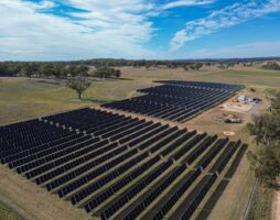
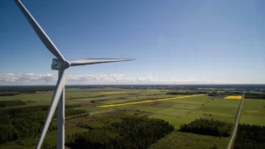
The AGL-backed Gippsland Skies, proposed for development off the coast of Victoria, is among the first round of Australia’s first offshore wind developments to head into the EPBC process, to get green clearance on the the early stages of its work on the proposed 2.5 gigawatt (GW) project.
The federal environment minister has decided that work around geophysical, geotechnical, seabed habitat, wind and oceanography surveys is not a controlled action – so long as it meets a series of conditions to protect cetaceans, the group of mammals that includes whales, dolphins and porpoises.
If whales, dolphins or porpoises pop up within 500m of any work, survey vessels must drop their speed to a crawling six knots, and any surveys specifically looking for cetaceans can only travel at 10 knots.
For context, boats are limited to five knots when close to shore or human swimmers.

No geotechnical or geophysical surveys are allowed between 1 May and 31 October, in the southern right whale calving grounds in the Bass Strait.
Geophysical surveys use a sonar and echo sounder to map the seafloor, according to the Climate Council. A geotechnical survey takes core samples by drilling into the seafloor, and samples from on top of the seabed.
Marine mammal observers must shut down project work if more than one whale or dolphin is seen during a geotechnical survey, or when sonar is used until all cetaceans are out of the area or 30 minutes after the last sighting.
And if cetacean sightings have shut down operations three times or more during low-visibility conditions, which covers everything from night-time, rainfall, fog, rough seas and high winds, then everything shuts down for 24 hours.
Jobs for Aussie Atlantis seekers
But before any drilling can begin, there is a job available for a little-known profession: an underwater archaeologist.
This person must look at the geophysical surveys – those taken with sonar and echo sounders – to make sure the bores are at least 100m away from any underwater cultural heritage site.
Heritage Victoria says there are some 660 shipwrecks off the state’s coastline and only 330 have been found.
Possible historical sites the ocean surveys may turn up include the anchor belonging to a George Bass’ ship, one of Australia’s earliest colonial explorers, lost in east Gippsland in 1797, or a 19th century whaling vessel also in that area reported by an abalone diver in the 1960s.
One step at a time
The AGL-backed Gippsland Skies project entered the EPBC process in early November. It joins the 2.5GW Great Eastern project which referred its project to the EPBC at the end of March, as well as other projects being developed in the zone.
Gippsland Skies first application – which still took five months to elicit a response – was just for the early marine surveys. Supporting documents do show that between 104 and 167 turbines are planned for the site and will have a tip height around 300m.
Also unlike Great Eastern, the more southern wind farm must build a longer cable — 137km — from its spot to the south of Wilson’s Promontory national and marine park up to the collector point near Giffard in Gippsland.
It has to work around the nearby Beagle marine park, the Ninety Mile Beach marine park which surveys will need to go right up to the edge of, and Ramsar-listed wetlands near the cable corridor.
The Gippsland Skies zone is also on migration pathways for birds such as the critically endangered orange-bellied parrot, a species that has been carried across the strait in aeroplanes to give them a shot at survival, sharks and cetaceans.