
The powerful El Nino event continues to strengthen in the Pacific, with sea-surface temperatures about one full degree Celsius above previous record events at this stage of the season, according to data posted to social media by leading climate scientist, Zeke Hausfather.
In a chart posted to X on Tuesday, Hausfather showed the Nino 3.4 region – a key “pulse point” area in the central and eastern equatorial Pacific – at temperatures 2.9 degrees above average.
“We’ve now surpassed 1982/1983 and are only behind 2015/2016 in terms of maximum daily values,” Hausfather wrote. “And it’s only September.”
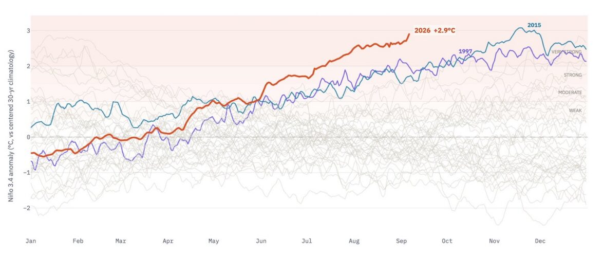
The readings reinforce projections by Australia’s Bureau of Meteorology that the present El Nino will exceed previous recorded ones.
- “All models, including the bureau’s, forecast the tropical Pacific to continue warming through the southern hemisphere spring, likely peaking in late spring or summer,” the Bureau said recently.
“Relative-Niño3.4 values are forecast to reach levels above the warmest observed since reliable records began in 1950,” BoM said.
“Given its current strength, in addition to the typical life cycle of an El Niño, this event is expected to persist into autumn 2027.”
The effects of El Ninos on Australian weather varies, with influences for the Indian and Southern oceans also playing roles. Indonesia and parts of Papua New Guinea are already reporting drier than usual conditions.
Still, global temperatures are expected to increase because of the El Nino, adding warmth the increases already under way because of climate change.
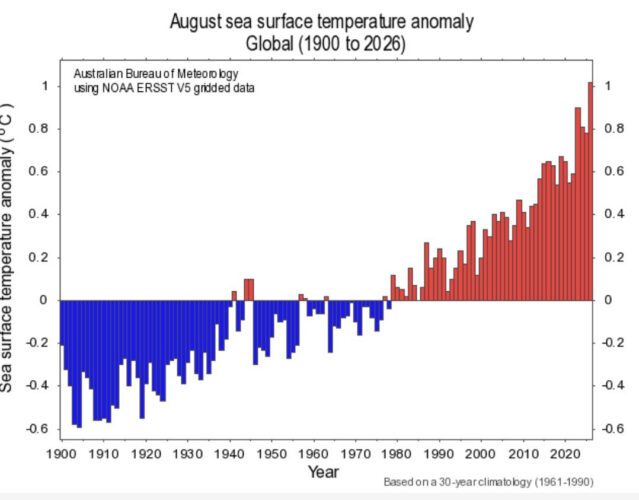
August sea-surface temperatures were also at a record high globally, BoM data shows.
Parts of Australia are already hitting temperature records.
Sydney’s Observatory Hill, for instance, recorded 32.1 degrees on 5 September, that was the hottest reading for the city in almost 170 years of records.
“The previous earliest occurrence of such a high temperature was 13 September in 2009 and 2017,” the Bureau told Renew Economy.