Scientists at Arizona State University have announced a new computer simulation that displays a city’s greenhouse-gas emissions in unprecedented detail, showing how much heat-trapping carbon dioxide is generated by individual buildings and highways.
The model, known as Hestia (after the Greek goddess of the hearth), and described in a paper in the October 9 issue of Environmental Science and Technology, could give cities a much better handle on how to reduce their emissions most efficiently.
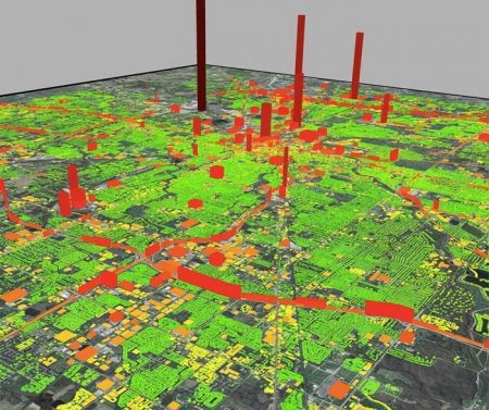
 Quantification of fossil fuel CO2 emissions in Indianapolis.
Click image to enlarge.
Credit: Bedrich Benes & Michel Abdul-Massih/Purdue University.
The idea is that while cities might be able to guess at where their CO2 emissions mostly come from, it’s more useful to know precisely where the hotspots are — a neighborhood of older houses, for example, or a handful of energy-wasting factories, or a frequently snarled intersection or merge point on a highway. By concentrating on these, a city could make significant improvements in its overall emissions picture with relative ease.
“We want to help them get the greatest reductions per dollar, the biggest bang for the buck,” said project leader Kevin Gurney, of Arizona State University.
This isn’t the first attempt to quantify local emissions though, Gurney said. “Cities do measure their carbon footprint, but each one uses its own method. Some of them are good, some not so good.” Emissions estimates that cover larger areas exist, but they aren’t all that useful as guides to targeted reductions.
In fact, Gurney’s group at Arizona State has already created one of these coarse-grained emissions inventories. CalledVulcan, it estimates and maps major CO2 sources in the U.S. down to the county level, including major power plants, highways and big, concentrated sources of emissions from the burning of coal, oil and gas. “Vulcan,” Gurney said, “gets us down to the county level.”
The Hestia project relies on Vulcan’s county-level information, but draws on all sorts of finer-scale data to pinpoint exactly where emissions are coming from. “For buildings, we mine tax records, which gives us a surprising amount of information, including the square footage, the height, how old the building is, what fuel it uses for heating, and more,” Gurney said.
Then he and his team run individual building-energy models designed for estimating heating and air-conditioning needs, to figure out how much energy and of what kind, a specific structure uses. “We don’t know how much glass is in each building,” Gurney said, which is pertinent to energy efficiency, “but we can use Department of Energy regional survey data on average pane thickness on retail buildings, say, of a certain size.”
 Quantification of fossil fuel CO2 emissions in Maricopa County, AZ.
Click image to enlarge.
Credit: Semih Yildiz/ASU.
For roadways the team looks not at total traffic per day on a city’s highways, but at the hour-by-hour statistics for specific stretches of road that municipalities gather to monitor traffic flow. As with the building analysis, Gurney said, “it’s a combination of leveraging what we already know from Vulcan and then adding more detailed information from other sources. We know where everything is.”
The process is clearly very labor-intensive, and so far, the Hestia team has only completed a map for Indianapolis, although maps for Los Angeles and Phoenix are nearing completion as well, and the project will eventually cover hundreds of metropolitan areas. “We’ve had good reaction from the cities we’ve worked with so far,” Gurney said, “but the concept is coming from out of far left field, so they aren’t quite sure how they’ll use all of the data yet.”
He doesn’t think it will take long, however. Mitigating climate change feels like a national problem, too overwhelming for a local government to deal with, Gurney said. “If we can get it down to things that look familiar — a house, a power plant, a commercial building — cities can start addressing it more effectively.“
Gurney even sees the emissions reductions Hestia might help accomplish as a kind of marketing tool. “It’s a great way to sell a city,” he said. Everyone’s fighting for businesses, jobs. Lowering carbon emissions is a way to show that a city is progressive about energy efficiency and fighting pollution.”