The NSW government has blotted out nearly the entire state as “less suitable” for wind farms, with few if any areas deemed “desirable” for new projects under new draft planning guidelines issued on Tuesday.
The guidelines, which include hefty new fees for wind and solar projects to provide funds to local communities as a way of overcoming social licence issues, are ostensibly about fast-tracking the planning process for new projects.
Some developers, however, have deemed the new fees as a form of tax. But the maps published with the new guidelines present an even greater problem.
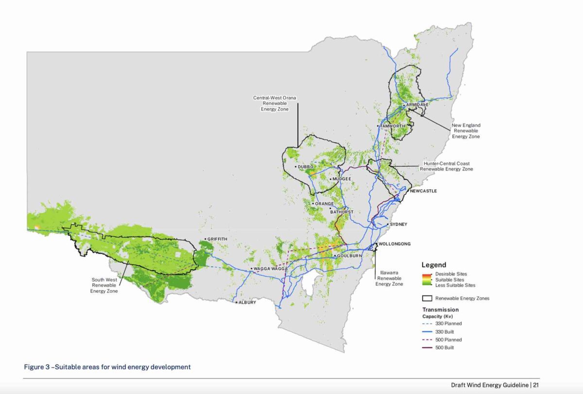
They highlight huge swathes of the state deemed “desirable” or suitable for solar farms – mostly on or close to existing or proposed transmission lines – but few or no areas deemed desirable for wind projects – a form of energy considered essential for the transition away from the state’s ageing coal fired generators.
Particularly noticeable is the New England area, where federal Nationals MP Barnaby Joyce has been leading a raucous campaign against wind farms in particular, but also solar projects and new transmission lines. There is no part of New England deemed “desirable” in the guidelines.
The new map provided by the state government (above) shows only a tiny amount of sites deemed “suitable” west of Goulburn – ironically in the Hume electorate of one of the most vocal anti-wind campaigners of all, former energy minister Angus Taylor – and near Dubbo.
The suitable sites are highlighted in yellow. “Desirable” are highlighted in red, and “less suitable” in green.
“It seems wrong … a tiny amount of sites near Goulburn and Dubbo. Ouch!” said one renewable energy developer. “It must be a mistake.”
But apparently not. The document notes that “it is challenging” to find any sites for wind energy that do not have “significant conflicts”. Wind farms have proved particularly problematic in the NSW planning pipeline, with only one project approved in the last four years, according to the industry.
More recently, apart from the Joyce-led campaign against onshore wind projects, a few vocal groups have been fuelling opposition to proposed new offshore wind zones in the Illawarra and Newcastle, including spreading fake reports about their impact on whales.
The renewable energy industry has already had a set back with the delay to so-called “access rights” – which were to be offered to new projects hoping to secure a place on the grid that would not be constrained. The first tender for access rates has been cancelled and pushed back another six months.
The planning guidelines published by the state government say the map shows “the most desirable areas for wind energy development considering key commercial factors and high-level environmental constraints.”
It says these wind resource potential, the proximity to existing and planned transmission infrastructure, access to major energy users, available network capacity, development and land use, land value, land use zoning, areas of high biodiversity value, and distance to major towns and population centres, national parks and reserves.
The guidelines – the first since 2016 – also include more clarity about setbacks, including a 2km setback for homes with visibility of the turbines, and 500 metre setbacks for recreational areas and national parks.
“Due to the large scale of wind energy development, it is challenging to find sites that do not have significant conflicts,” the document says.
“Projects must also be designed in a cost-effective manner to provide benefits to energy consumers and reduced electricity costs.
“Overall, the site selection process should avoid impacts as far as possible. Projects should then be designed to strike an appropriate balance between competing environmental, commercial, and social factors.”
See the contrast with the solar map below.
RenewEconomy has reached out to the state government to seek further comment on the proposal.
In a statement sent later, the state Department of Planning and Environment said the draft wind energy guideline maps indicate the most desirable areas for wind energy development taking into account a range of technical, economic, and environmental factors.
“This is a tool which provides an indication of where development is likely to be located (particularly the distance from existing or planned transmission and access to good quality wind resources),” the statement said.
“The mapping does not preclude development outside of the mapped areas, nor does it affect the assessment process for projects in these areas.
“Wind energy development is much more constrained than solar because the wind resource is less prevalent.
“Therefore, it is more difficult to find suitable sites for wind energy across the state when directly compared to solar.”
The Clean Energy Council also responded.
“Our understanding is that the map is intended to provide an indication to the community that wind farms can’t simply be built in the far west of the state,” said Nicholas Aberle, the CEC director for Energy Generation and Storage.
“Importantly, projects won’t be assessed against the colours on this map. The map might be better labelled as “more likely” and “less likely” areas for wind development – marking large parts of the state, including within existing REZs, as “less suitable” is unhelpful at an early stage of consultation.
“We are working through the details of the proposed guidelines, to understand how DPE will actually assess wind projects.
“The NSW government is keenly aware that they cannot meet their own energy objectives without wind energy, so we fully expect that the final guidelines will support rapid and responsible development of the industry.”


