By David Jones, Australian Bureau of Meteorology; Blair Trewin, Australian Bureau of Meteorology; Karl Braganza, Australian Bureau of Meteorology, and Rob Smalley, Australian Bureau of Meteorology
The last 10 months have been abnormally warm across Australia and we’ve seen a notable lack of unusually cold weather this winter. Are we heading for the hottest year on record?
The more significant records for this period include:
- Australia’s hottest day on record
- Australia’s hottest week on record
- Australia’s hottest month on record
- Australia’s hottest summer on record
- Australia’s hottest September to June (10 months) on record
A feature of the last 10 months has been the persistence of unusually warm temperatures. Every calendar month since September 2012 has had temperatures 0.5°C or more above normal. The result has been a national mean temperature anomaly of +1.03°C for the past 10 months, well ahead of the previous record of +0.94 °C set in 1997-98.

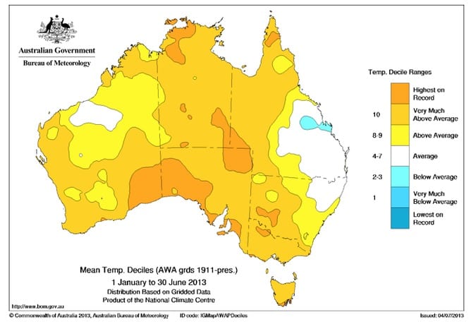
Year to date temperatures deciles for Australia showing that temperatures have been above average to record warm over nearly the whole continent in 2013. Bureau of Meteorology
The record heat has affected rural, regional and urban Australia alike, with many stations setting records. Hobart (41.8 °C) and Sydney (45.8 °C) both recorded their hottest days on record. The last 10 months have seen above-normal temperatures over 97% of Australia; only the Capricornia district of central Queensland has missed out.
The heat has extended to the oceans around Australia, with record warm sea-surface temperatures during summer (January and February 2013) as well as the warmest start to a calendar year (January to June) on record.

Year to date sea surface temperature deciles around Australia showing that temperatures have been above average to record warm in most oceans around Australia in 2013. Bureau of Meteorology
Record heat following the demise of La Niña
Australia’s climate has been on a roller coaster in recent years. 2009 was a particularly hot year: there was a nation-wide anomaly of +0.81 °C and it was the third-warmest year since national records began in 1910. 2010 (with 704mm and third wettest) and 2011 (with 708mm and second wettest) were very wet years Australia-wide. 2012 was a year of transition from a significant La Niña event with widespread flooding and heavy rain to abnormally hot and dry conditions from September onwards. This heat eventually culminated in the record hot summer of 2012-13 which – in combination with dry conditions – led to severe and widespread bushfire activity in southern Australia.
The past few years highlight a number of features of the Australian climate, and provide some context to the recent unusually hot period.
Perhaps the most obvious is the role played by the regular and (mostly) natural cycles from El Niño (typically dry and warm) to La Niña (typically wet and cooler) conditions across Australia.
Australian temperatures from late 2010 to mid-2012 were kept relatively cool by two major La Niña events and record high rainfall, which caused flooding affecting much of the country. The cooler conditions were a direct result of the high rainfall during these two years. Widespread, excess rain over the continent acts like a large evaporative cooler, suppressing daytime temperatures in particular. Additional cloud cover also cools daytime temperatures, especially in summer.

Year to date mean temperature anomaly for Australia, indicating that the three warmest January to June periods (2005, 2013 and 1998) stand well above any others. Bureau of Meteorology
The national mean temperature from September 2010 to August 2012 was 0.27°C below the 1961-1990 average. Rainfall was the highest on record, with 1365mm falling on Australia against a two-year average of just 930mm.
Another feature of recent climate in Australia is that background trends have continued; in the case of temperature, the warming trend is adding a warming bias to the natural variability. This was apparent even during the two recent La Niña years. While late 2010 through early 2012 were slightly cooler than the 1961-1990 average, the period was warmer than comparable wet periods of the past, such as those which occurred during the 1970s and 1950s. In other words, while the temperatures were below average, the warming trend held the values higher than they should have been (without the trend) given the amount of rain that fell.
The warming trend over Australia now means that, in the absence of year-to-year natural variability, a calendar year can be expected to be (on average) around +0.35°C above the 1961-1990 base period, or about 0.9 °C warmer than the temperatures during the early decades of the 20th Century. Every year – wet, dry or with near average rainfall – is affected by this warming trend. It favours the occurrence of abnormally hot years, and a reduction in the number of cool years. This is most obviously seen at the annual scale where typically only one year in ten is now below average.

Year to date temperature anomalies for Australia (January to June 2013) showing a range of scenarios (see table) compared with past July to December outcomes. The light blue shaded area shows the range of historical outcomes from hottest to coldest. Continuation of the current anomaly will see 2013 fall just short of a new Australian annual mean temperature record. Bureau of Meteorology
How is 2013 likely to end up?
While it is not possible to accurately predict temperatures by month for the rest of 2013, it is possible to look at recent temperatures and longer-term trends to develop a range of scenarios for how the year may end.
Two sets of numbers summarise the current situation, and allow us to determine the range of values under which 2013 temperatures might fall. The first is the year-to-date (January 1 to June 30 2013) Australian mean temperature anomaly. At the end of June, 2013 is currently sitting equal second-warmest on record with an anomaly of +0.99°C, some 0.17°C behind the warmest on record in 2005 (January to June). On face value, it appears that the current year has some catching-up to do to surpass 2005 as a record hot calendar year.
The three warmest January to June periods on record are 2005 (+1.16°C); 2013 (+0.99°C); 1998 (+0.99°C).
However, if we look at the hottest years, we find that 2013 is, perhaps, closer to beating the 112 year record than might first appear to be the case.
Calendar year 2005 saw falling temperatures (or more precisely, less positive temperature anomalies) during the second half of the year. If the temperature anomalies seen so far to the end of June 2013 were to persist until year’s end, 2013 will fall just short of being the nation’s hottest year on record.
The three hottest calendar years on record are 2005 (+1.03°C); 1998 (+0.85°C); 2009 (+0.81°C).
A range of scenarios for 2013 temperatures are provided in the table below and displayed in the accompanying graph.

Possible ‘hottest year’ ranking for 2013. Bureau of Meteorology
Arguably, the first three are the more likely scenarios for the remainder of 2013, and show that it is likely that 2013 will finish as one of Australia’s warmest years on record.
We know that, in the absence of a significant La Niña event and excessive rain, Australian mean temperatures are unlikely to be below normal over the remainder of the year (July to December): only two of the last 20 years have seen below-normal July to December temperatures. On the warm side, a record hot finish to the year would see Australia pass the annual temperature record currently held by 2005. The second half of 2013 needs to run near record cold for the 2013 annual anomaly to fall below 0.0°C, a scenario that is statistically possible, but regarded as highly unlikely.
The Bureau’s National temperature outlook for August to October was issued on 24 July 2013. This outlook suggests below average maximum temperatures are more likely in eastern Australia. This is largely offset by shifts towards above average maximum temperatures in northern and western areas. For minimum temperatures, most parts of Australia show a shift towards above average temperatures, which are particularly strong in the tropics. This reinforces the expectation that the coming months will be warmer than average overall.
In summary, at the mid point of 2013 we can be quite confident that the current year will be one of Australia’s warmest years on record. It is possible that 2013 will set a new record high if the remainder of the year tracks slightly warmer than the first six months have been. The unusually warm ocean temperatures currently surrounding Australia and the continued influence of the enhanced greenhouse effect mean that an unusually warm end to the year remains likely.
The Bureau of Meteorology provides Australians with environmental intelligence for their safety, sustainability, well-being and prosperity. Our weather, climate and water services include observations, alerts, warnings and forecasts for extreme events. David Jones does not consult to, own shares in or receive funding from any company or organisation that would benefit from this article, and has no relevant affiliations.
The Bureau of Meteorology provides Australians with environmental intelligence for their safety, sustainability, well-being and prosperity. Our weather, climate and water services include observations, alerts, warnings and forecasts for extreme events. Blair Trewin does not consult to, own shares in or receive funding from any company or organisation that would benefit from this article, and has no relevant affiliations.
The Bureau of Meteorology provides Australians with environmental intelligence for their safety, sustainability, well-being and prosperity. Our weather, climate and water services include observations, alerts, warnings and forecasts for extreme events. Karl Braganza does not consult to, own shares in or receive funding from any company or organisation that would benefit from this article, and has no relevant affiliations.
The Bureau of Meteorology provides Australians with environmental intelligence for their safety, sustainability, well-being and prosperity. Our weather, climate and water services include observations, alerts, warnings and forecasts for extreme events. Rob Smalley does not consult to, own shares in or receive funding from any company or organisation that would benefit from this article, and has no relevant affiliations.
![]()
This article was originally published at The Conversation.
Read the original article.


