The giant El Nino climate pattern in the Pacific is nearing record weekly levels, with the previous high reached about two full months later in spring, the Bureau of Meteorology said in its latest update.
The chart, shown below, clocked sea-surface temperature anomalies in the so-called Nino3.4 region of the eastern equatorial Pacific at 2.72 °C in the week ending 27 September, well above the 0.8°C level considered by BoM as the El Niño threshold.
The only higher reading in the bureau’s weekly data since 2008 was the 2.76 °C reading for the week ending 22 November 2015.
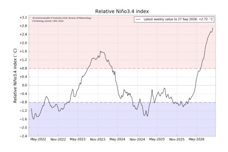
Perhaps more worrying that BoM said all of the models that it tracks, including its own, forecast the tropical Pacific will continue warming through the southern hemisphere spring. The El Nino is likely to peak only in the late spring or summer, and persist into next autumn.
“Relative-Nino3.4 values are forecast to reach levels above the warmest observed since reliable records began in 1950, with the majority of models indicating a peak value above 3.0 °C,” the bureau said.
The impacts of the El Nino are already being felt in Indonesia and Papua New Guinea, among other areas. The event may also push global temperatures to annual records in 2026 but 2027 is likely to be hotter again.
For Australia, the weather will be influenced also by conditions in the Indian Ocean. Unfortunately, there too the outlook is not promising.
- The Indian Ocean Dipole (IOD), see chart below, is a measure of relative differences between the west and east of the Indian Ocean basin.
- The IOD is currently neutral although the index value for the week ending 27 September 2026 was sitting 0.76 °C.
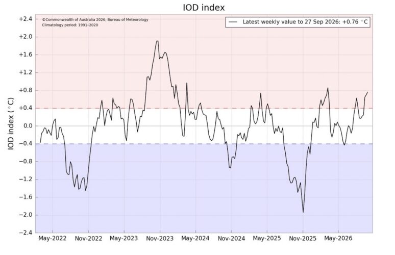
“This is the third consecutive week that the index has exceeded the positive IOD threshold (0.4 °C),” the bureau said. “Sustained values above this threshold are required before an event is considered established.”
However, the bureau added that a “positive IOD is likely to develop during the southern hemisphere spring and persist into early summer, although model guidance indicates some uncertainty in the strength and duration of the event”.
Positive IODs tend to be associated with reduced rainfall, particularly over southeastern Australia – but every event is different.
According to the bureau’s most recent long-range forecasts, published on 24 September, the odds favour rainfall being below-average during the October-December period in the south-east and far northern regions of Australia.
- Other parts of the country, including areas to the south of Brisbane and most of the western half of Australia, are looking at wetter than normal conditions.

The temperature outlook, on the other hand, is much more uniform.
Both daytime and overnight temperatures are heavily favoured to be warmer than usual, the bureau said.

Above-average temperatures are increasingly likely, given the background warming from climate change.
According to the 2024 State of the Climate Report issued by BoM and CSIRO, Australia’s climate has warmed about 1.5 degrees since national records began in 1910.
The next iteration of the biennial report is expected to be released later this year.
To join more than 29,000 others and get the latest clean energy news delivered straight to your inbox, for free, click here to subscribe to our free daily newsletter.